Geography Students, Professor Restore Cemeterys Lost Data
Thu, 06/30/2011 - 10:47am | By: Charmaine Williams Schmermund
In an effort to restore valuable information the City of Long Beach lost when Hurricane Katrina struck in 2005, University of Southern Mississippi Gulf Coast students and assistant professor of geography, Dr. David Holt have spent the past six months piecing together research and data for the city's cemetery.
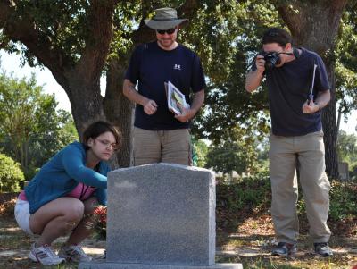
The project, funded by a $7,250 grant from the Learn and Serve America program, involved Holt and more than 50 geography students working diligently on mapping, photographing and researching each plot within the 100-year-old cemetery.
“Projects like these are invaluable to the education of the modern student,” said Holt, who teaches students in both the geography bachelor's and master's degree programs. “This gets our students out into the communities and shows them how to generate and maintain real-world data, all the while benefiting the community in which they work.”
The cemetery's records, stored in City Hall when the hurricane made landfall, were lost after the building received damage from the storm. Long Beach Mayor Billy Skellie said he finds the research and data extraordinarily helpful. Following Holt's presentation to the mayor and city clerk, Skellie said that he “appreciates the academic service learning program, the grant sources and Southern Miss Gulf Coast for providing such diligent students and faculty.”
“It's great to have this work done by such a capable group of people,” he said. “Now the City of Long Beach has this comprehensive information to work with and we can continue to pass on this invaluable information for years to come.”
Holt and his students used a variety of methods to investigate and document the cemetery's occupied and unoccupied graves. In addition to an aerial image of the cemetery, the researchers used a map, photography and a newly developed coding system to document each plot's location within the cemetery. Information from remaining city records and the cemetery's headstones were also documented for the researchers' data.
“Geographic information system (GIS) is a problem solving discipline,” said Holt. “Once the students go into the field, they quickly realize the issues with generating the simplest of datasets and must use problem-solving skills to generate useful data.”
With the research completed, city officials will now be able to access the cemetery's data using an interactive map and spreadsheet. With this information, city officials can conduct various searches on either the map or spreadsheet all within the computer program.
JinJoo McClendon, program director for the Learn and Serve America program, was thoroughly impressed with the project during Holt's presentation to the mayor.
“This is one of the top projects we have,” said McClendon. “There are a lot of projects in the learning service program that involve the classroom, but this is unique in what students were learning outside the classroom.”
While the project with the city's cemetery is complete, Holt hopes to continue assisting the city of Long Beach with other projects. If Holt can secure a two-year funded grant, his next project would be completing all the addresses in Long Beach for 911 services. Additionally, with a two-year grant, they would be able to extend this project to Pass Christian and mark the high water elevations of Long Beach's infrastructure.
For more information about Southern Miss Gulf Coast, visit www.usm.edu/gulfcoast.